
太师屯镇 topographic map
Interactive map
Click on the map to display elevation.
About this map
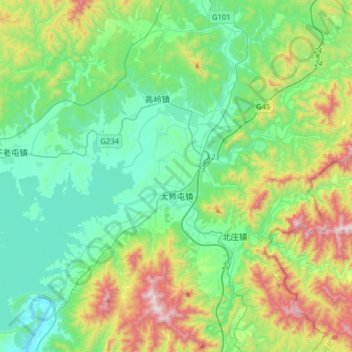
Name: 太师屯镇 topographic map, elevation, terrain.
Location: 太师屯镇, 密云区, 北京市, 中国 (40.44773 116.98503 40.65018 117.30344)
Average elevation: 334 m
Minimum elevation: 90 m
Maximum elevation: 1,001 m
Other topographic maps
Click on a map to view its topography, its elevation and its terrain.