Geolocate

Meissen topographic map

Click on the map to display elevation.

About this map

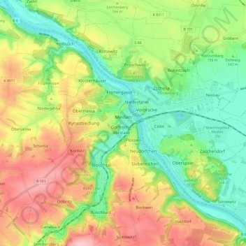
Name: Meissen topographic map, elevation, terrain.

Location: Meissen, Saxony, Germany (51.12916 13.42420 51.19317 13.54228)

Average elevation: 163 m

Minimum elevation: 85 m

Maximum elevation: 265 m

Other topographic maps

Click on a map to view its topography, its elevation and its terrain.

Meissen

Germany > Saxony > Meißen

Average elevation: 162 m

Niederstößwitz

Germany > Saxony > Meißen > Käbschütztal

Average elevation: 191 m

Mauna

Germany > Saxony > Meißen > Käbschütztal > Krögis

Average elevation: 205 m

Constappel

Germany > Saxony > Meißen

Average elevation: 158 m

Kleinprausitz

Germany > Saxony > Meißen > Käbschütztal

Average elevation: 203 m

Neurobschütz

Germany > Saxony > Meißen > Robschütz

Average elevation: 205 m

Brettmühlenteich

Germany > Saxony > Meißen > Tauscha

Average elevation: 155 m

Nossen

Germany > Saxony > Meißen > Nossen

Average elevation: 273 m

Streumen

Germany > Saxony > Meißen > Streumen

Average elevation: 102 m