
Make a donation
Dallas County topographic map
Click on the map to display elevation.
Make a donation
About this map
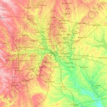
Name: Dallas County topographic map, elevation, terrain.
Location: Dallas County, Texas, United States (32.06204 -97.47901 33.46204 -96.07901)
Average elevation: 182 m
Minimum elevation: 78 m
Maximum elevation: 345 m
Make a donation
Other topographic maps
Click on a map to view its topography, its elevation and its terrain.
Marfa
United States > Texas > Presidio County
Marfa is a city in the high desert of the Trans-Pecos in far West Texas, United States, between the Davis Mountains and Big Bend National Park, at an elevation of 4685 feet. It is the county seat of Presidio County, and its population as of the 2020 United States Census was 1,788. The city was founded in the…
Average elevation: 1,434 m
Make a donation
Make a donation
Make a donation
Make a donation
Shavano Park
United States > Texas > Bexar County
Despite lying in the far southeastern reaches of the Texas Hill Country, Shavano Park's terrain is flat to gently rolling. Most of the city is between 950 and 1,000 feet above sea level, which contrasts sharply with neighborhoods just north of Anderson Loop, where hills can rise 200 feet in a short distance.…
Average elevation: 293 m
Make a donation
Franklin Mountains State Park
United States > Texas > El Paso County > El Paso
Franklin Mountains State Park is a Texas state park in El Paso, Texas, that protects the Franklin Mountains. Park headquarters are located at an elevation of 5,426 feet (1,654 m) with the highest peak, North Franklin Mountain, reaching 7,192 feet (2,192 m). It is one of the largest urban parks in the nation…
Average elevation: 1,293 m
Make a donation
Davis Mountains State Park
United States > Texas > Jeff Davis County > Fort Davis
Average elevation: 1,603 m
Make a donation
Make a donation
Make a donation
Make a donation
Make a donation
Make a donation
Make a donation
Make a donation
Make a donation
Make a donation
Make a donation
Summerfields/Chisholm Park
United States > Texas > Tarrant County > Fort Worth
Average elevation: 203 m
Make a donation
Make a donation
Make a donation
Make a donation
Make a donation
Make a donation
Make a donation
Make a donation