
Thank you for supporting this site ❤️
Make a donation
Make a donation
Wenns topographic map
Click on the map to display elevation.
Thank you for supporting this site ❤️
Make a donation
Make a donation
About this map
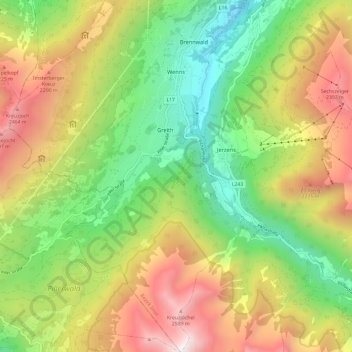
Name: Wenns topographic map, elevation, terrain.
Location: Wenns, Bezirk Imst, Tyrol, 6473, Austria (47.10438 10.67309 47.18555 10.75473)
Average elevation: 1,630 m
Minimum elevation: 788 m
Maximum elevation: 2,764 m
Thank you for supporting this site ❤️
Make a donation
Make a donation
Other topographic maps
Click on a map to view its topography, its elevation and its terrain.
Thank you for supporting this site ❤️
Make a donation
Make a donation
Thank you for supporting this site ❤️
Make a donation
Make a donation
Thank you for supporting this site ❤️
Make a donation
Make a donation
Thank you for supporting this site ❤️
Make a donation
Make a donation
Oberlängenfeld
Austria > Tyrol > Bezirk Imst > Gemeinde Längenfeld > Längenfeld
Average elevation: 1,584 m
Thank you for supporting this site ❤️
Make a donation
Make a donation
Unterlängenfeld
Austria > Tyrol > Bezirk Imst > Gemeinde Längenfeld > Längenfeld
Average elevation: 1,590 m
Thank you for supporting this site ❤️
Make a donation
Make a donation