
Thank you for supporting this site ❤️
Make a donation
Make a donation
Pest vármegye topographic map
Click on the map to display elevation.
Thank you for supporting this site ❤️
Make a donation
Make a donation
About this map
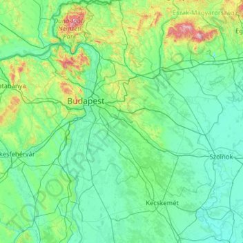
Name: Pest vármegye topographic map, elevation, terrain.
Location: Pest vármegye, Pest, Central Hungary, Hungary (46.67159 18.64526 48.07159 20.04526)
Average elevation: 156 m
Minimum elevation: 76 m
Maximum elevation: 1,010 m
Thank you for supporting this site ❤️
Make a donation
Make a donation
Other topographic maps
Click on a map to view its topography, its elevation and its terrain.
Budapest
The wide Danube was always fordable at this point because of a small number of islands in the middle of the river. The city has marked topographical contrasts: Buda is built on the higher river terraces and hills of the western side, while the considerably larger Pest spreads out on a flat and featureless sand…
Average elevation: 171 m