
Thank you for supporting this site ❤️
Make a donation
Make a donation
Macon topographic map
Click on the map to display elevation.
Thank you for supporting this site ❤️
Make a donation
Make a donation
About this map
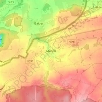
Name: Macon topographic map, elevation, terrain.
Location: Macon, Momignies, Thuin, Henegouwen, Wallonië, 6591, België (50.03212 4.18963 50.07212 4.22963)
Average elevation: 230 m
Minimum elevation: 139 m
Maximum elevation: 285 m
Thank you for supporting this site ❤️
Make a donation
Make a donation
Other topographic maps
Click on a map to view its topography, its elevation and its terrain.
Merbes-le-Château
België > Henegouwen > Thuin
Merbes-le-Château ligt aan de Sambre. De hoogte aan de kerk bedraagt 133 meter.
Average elevation: 157 m
Thank you for supporting this site ❤️
Make a donation
Make a donation
Thank you for supporting this site ❤️
Make a donation
Make a donation
Thank you for supporting this site ❤️
Make a donation
Make a donation
Beaumont
België > Henegouwen > Thuin
Beamont ligt betrekkelijk hoog. Het stadje ligt ook aan de Belgisch-Franse grens. De Hantes stroomt langs Beaumont. De hoogte aan de kerk bedraagt 221 meter.
Average elevation: 208 m
Thank you for supporting this site ❤️
Make a donation
Make a donation
Thank you for supporting this site ❤️
Make a donation
Make a donation