
Thank you for supporting this site ❤️
Make a donation
Make a donation
Anderlues topographic map
Click on the map to display elevation.
Thank you for supporting this site ❤️
Make a donation
Make a donation
About this map
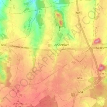
Name: Anderlues topographic map, elevation, terrain.
Location: Anderlues, Thuin, Henegouwen, Wallonië, 6150, België (50.37984 4.22782 50.42805 4.29398)
Average elevation: 183 m
Minimum elevation: 119 m
Maximum elevation: 223 m
Thank you for supporting this site ❤️
Make a donation
Make a donation
Other topographic maps
Click on a map to view its topography, its elevation and its terrain.
Thank you for supporting this site ❤️
Make a donation
Make a donation
Thank you for supporting this site ❤️
Make a donation
Make a donation