
Angleur topographic map
Interactive map
Click on the map to display elevation.
About this map
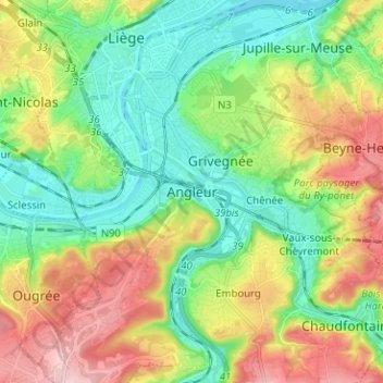
Name: Angleur topographic map, elevation, terrain.
Location: Angleur, Luik, Wallonië, 4000, België (50.57284 5.55531 50.65284 5.63531)
Average elevation: 135 m
Minimum elevation: 54 m
Maximum elevation: 271 m
Other topographic maps
Click on a map to view its topography, its elevation and its terrain.
Citadel van Luik
Citadel van Luik, Boulevard du 14e de Ligne, Le Péri, Luik, Wallonië, 4000, België
Average elevation: 116 m
Jupille-sur-Meuse
Jupille-sur-Meuse, Luik, Wallonië, 4000, België
Average elevation: 133 m