
Thank you for supporting this site ❤️
Make a donation
Make a donation
Rocourt topographic map
Click on the map to display elevation.
Thank you for supporting this site ❤️
Make a donation
Make a donation
About this map
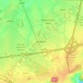
Name: Rocourt topographic map, elevation, terrain.
Location: Rocourt, Luik, Wallonië, 4000, België (50.65804 5.52762 50.69804 5.56762)
Average elevation: 173 m
Minimum elevation: 124 m
Maximum elevation: 227 m
Thank you for supporting this site ❤️
Make a donation
Make a donation
Other topographic maps
Click on a map to view its topography, its elevation and its terrain.