
Blickweiler topographic map
Interactive map
Click on the map to display elevation.
About this map
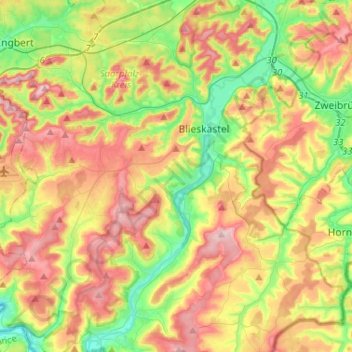
Name: Blickweiler topographic map, elevation, terrain.
Average elevation: 294 m
Minimum elevation: 197 m
Maximum elevation: 408 m
Other topographic maps
Click on a map to view its topography, its elevation and its terrain.
Lautzkirchen
Deutschland > Saarland > Blieskastel > Lautzkirchen
Lautzkirchen, Blieskastel, Saarpfalz-Kreis, Saarland, 66440, Deutschland
Average elevation: 265 m
Riesweiler
Deutschland > Saarland > Blieskastel > Riesweiler
Riesweiler, Blieskastel, Saarpfalz-Kreis, Saarland, Deutschland
Average elevation: 306 m