
Thank you for supporting this site ❤️
Make a donation
Make a donation
Panorama Ridge topographic map
Click on the map to display elevation.
Thank you for supporting this site ❤️
Make a donation
Make a donation
About this map
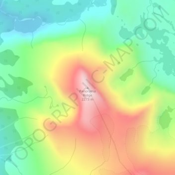
Name: Panorama Ridge topographic map, elevation, terrain.
Average elevation: 1,897 m
Minimum elevation: 1,631 m
Maximum elevation: 2,282 m
Thank you for supporting this site ❤️
Make a donation
Make a donation
Other topographic maps
Click on a map to view its topography, its elevation and its terrain.
Telegraph Creek
Canada > British Columbia > Central Coast Regional District > Area C (Hagensborg/Talchako/Atnarko)
Average elevation: 1,432 m
Vista Lake
Canada > British Columbia > Central Coast Regional District > Area C (Hagensborg/Talchako/Atnarko)
Average elevation: 1,159 m