
Dalian topographic map
Click on the map to display elevation.
About this map
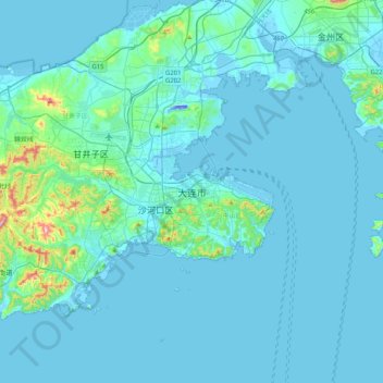
Name: Dalian topographic map, elevation, terrain.
Average elevation: 29 m
Minimum elevation: -31 m
Maximum elevation: 370 m
Other topographic maps
Click on a map to view its topography, its elevation and its terrain.
Shahekou District
The district's western portion is generally higher in elevation, and has seven notable peaks. The district has 8 kilometres (5.0 mi) of coastline.
Average elevation: 40 m
Shenyang City
Shenyang ranges in latitude from 41° 11' to 43° 02' N and in longitude from 122° 25' to 123° 48' E, and is located in the central part of Liaoning province. The western parts of the city's administrative area are located on the alluvial plain of the Liao River system, while the eastern part consists of the…
Average elevation: 155 m
Shenyang City
Shenyang ranges in latitude from 41° 11' to 43° 02' N and in longitude from 122° 25' to 123° 48' E, and is located in the central part of Liaoning province. The western parts of the city's administrative area are located on the alluvial plain of the Liao River system, while the eastern part consists of the…
Average elevation: 151 m
Anshan City
Local transportation is primarily by bus or taxi. Anshan used to have a single tram line—along Zhonghua Avenue, through the city centre and past Angang main gate—but this has been closed and the tracks removed. Due to the flat topography of the city centre, bicycles are popular. Almost all roads have a…
Average elevation: 145 m