
Make a donation
Shenyang City topographic map
Click on the map to display elevation.
Make a donation
Shenyang City
Shenyang ranges in latitude from 41° 11' to 43° 02' N and in longitude from 122° 25' to 123° 48' E, and is located in the central part of Liaoning province. The western parts of the city's administrative area are located on the alluvial plain of the Liao River system, while the eastern part consists of the hinterlands of the Changbai Mountains, and is covered with forests. The highest point in Shenyang is 414 m (1,358 ft) above sea level and the lowest point only 7 m (23 ft). The average elevation of the urban area is 45 m (148 ft).
Make a donation
About this map
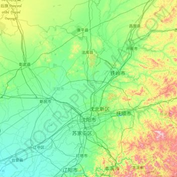
Name: Shenyang City topographic map, elevation, terrain.
Location: Shenyang City, Liaoning, China (41.19769 122.41674 43.04030 123.80854)
Average elevation: 151 m
Minimum elevation: 3 m
Maximum elevation: 1,084 m
Make a donation
Other topographic maps
Click on a map to view its topography, its elevation and its terrain.
Make a donation
Make a donation
Make a donation
Make a donation
Make a donation
Anshan
China > Liaoning > Shengli Subdistrict
Local transportation is primarily by bus or taxi. Anshan used to have a single tram line—along Zhonghua Avenue, through the city centre and past Angang main gate—but this has been closed and the tracks removed. Due to the flat topography of the city centre, bicycles are popular. Almost all roads have a…
Average elevation: 79 m
Anshan
China > Liaoning > Anshan > Shengli Subdistrict
Local transportation is primarily by bus or taxi. Anshan used to have a single tram line—along Zhonghua Avenue, through the city centre and past Angang main gate—but this has been closed and the tracks removed. Due to the flat topography of the city centre, bicycles are popular. Almost all roads have a…
Average elevation: 79 m
Make a donation
Hongqiyingzi
China > Liaoning > Xiuyan Manchu Autonomous County > Hongqiyingzi
Average elevation: 169 m