
City of Subiaco topographic map
Interactive map
Click on the map to display elevation.
About this map
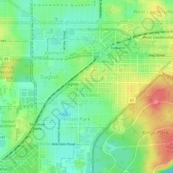
Name: City of Subiaco topographic map, elevation, terrain.
Location: City of Subiaco, Western Australia, 6008, Australia (-31.96451 115.80207 -31.94201 115.84174)
Average elevation: 29 m
Minimum elevation: 2 m
Maximum elevation: 69 m
Other topographic maps
Click on a map to view its topography, its elevation and its terrain.
Mount Meharry
The summit of Mt Meharry can be reached from the Great Northern Highway via an unsealed road 16 km (9.9 mi) in length and a vehicular track 21 kilometres (13 mi) in length. Permission should be sought from the managers of the land over which the road and track pass. These are Juna Downs Station and the…
Average elevation: 1,030 m