
Oblast de Rivne topographic map
Interactive map
Click on the map to display elevation.
About this map
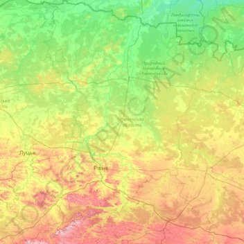
Name: Oblast de Rivne topographic map, elevation, terrain.
Location: Oblast de Rivne, Ucrânia (50.00405 25.08410 51.95001 27.73464)
Average elevation: 192 m
Minimum elevation: 124 m
Maximum elevation: 404 m
Other topographic maps
Click on a map to view its topography, its elevation and its terrain.
Гай
Гай, Радивилівський район, Oblast de Rivne, 35533, Ucrânia
Average elevation: 222 m