
Barbezieux topographic map
Interactive map
Click on the map to display elevation.
About this map
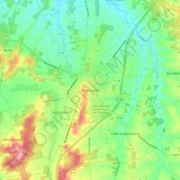
Name: Barbezieux topographic map, elevation, terrain.
Average elevation: 77 m
Minimum elevation: 38 m
Maximum elevation: 146 m
Other topographic maps
Click on a map to view its topography, its elevation and its terrain.
Ligne de Châteauneuf-sur-Charente à Saint-Mariens - Saint-Yzan
France > Nouvelle-Aquitaine > Charente > Barbezieux-Saint-Hilaire > Saint-Médard
Ligne de Châteauneuf-sur-Charente à Saint-Mariens - Saint-Yzan, Avenue Félix Gaillard, Saint-Médard, Barbezieux-Saint-Hilaire, Cognac, Charente, Nouvelle-Aquitaine, France métropolitaine, 16300, France
Average elevation: 59 m
Saint-Seurin
France > Nouvelle-Aquitaine > Charente > Barbezieux-Saint-Hilaire > Barbezieux
Saint-Seurin, Barbezieux, Barbezieux-Saint-Hilaire, Cognac, Charente, Nouvelle-Aquitaine, France métropolitaine, 16300, France
Average elevation: 78 m