Geolocate

桃花镇 topographic map

Interactive map

Click on the map to display elevation.

About this map

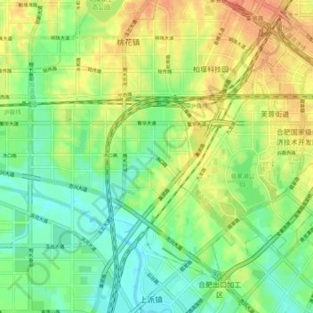
Name: 桃花镇 topographic map, elevation, terrain.

Location: 桃花镇, 肥西县, 合肥市, 安徽省, 231200, 中国 (31.74566 117.10972 31.80647 117.19987)

Average elevation: 29 m

Minimum elevation: 10 m

Maximum elevation: 52 m

Other topographic maps

Click on a map to view its topography, its elevation and its terrain.

李圩

中国 > 安徽省 > 肥西县 > 山南镇

李圩, 山南镇, 肥西县, 合肥市, 安徽省, 231200, 中国

Average elevation: 51 m

潜南干渠

中国 > 安徽省 > 肥西县 > 花岗镇

潜南干渠, 花岗镇, 肥西县, 安徽省, 231200, 中国

Average elevation: 39 m

上派镇

中国 > 安徽省 > 肥西县

上派镇, 肥西县, 合肥市, 安徽省, 231200, 中国

Average elevation: 25 m

神灵站主干渠

中国 > 安徽省 > 肥西县

神灵站主干渠, 三河镇, 肥西县, 合肥市, 安徽省, 231200, 中国

Average elevation: 12 m

山南镇

中国 > 安徽省 > 肥西县 > 山南镇

山南镇, 肥西县, 安徽省, 231200, 中国

Average elevation: 36 m