
Bousselam topographic map
Interactive map
Click on the map to display elevation.
About this map
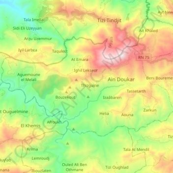
Name: Bousselam topographic map, elevation, terrain.
Location: Bousselam, Daïra Bouandas, Sétif, 19124, Algérie (36.45930 4.93346 36.52868 5.08360)
Average elevation: 816 m
Minimum elevation: 269 m
Maximum elevation: 1,626 m
Other topographic maps
Click on a map to view its topography, its elevation and its terrain.
Bouandas
Algérie > Sétif > Daïra Bouandas
Bouandas, Daïra Bouandas, Sétif, Algérie
Average elevation: 997 m
Aït Nawal M'zada
Algérie > Sétif > Daïra Bouandas
Aït Nawal M'zada, Daïra Bouandas, Sétif, Algérie
Average elevation: 1,022 m