
Ballstädt topographic map
Interactive map
Click on the map to display elevation.
About this map
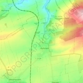
Name: Ballstädt topographic map, elevation, terrain.
Location: Ballstädt, Nessetal, Landkreis Gotha, Thüringen, Deutschland (51.02219 10.68126 51.05251 10.75806)
Average elevation: 287 m
Minimum elevation: 219 m
Maximum elevation: 380 m
Ballstädt liegt im Thüringer Becken, an den westlichen Ausläufern der Fahner Höhen, etwa in der Mitte zwischen Gotha, Erfurt und Bad Langensalza. Die Nachbarorte sind Hausen und Pfullendorf im Süden, Westhausen im Südwesten, Eschenbergen im Südosten, Aschara im Nordwesten und Burgtonna im Norden.
Other topographic maps
Click on a map to view its topography, its elevation and its terrain.
Hochheim
Deutschland > Thüringen > Landkreis Gotha > Nessetal
Hochheim, Nessetal, Landkreis Gotha, Thüringen, Deutschland
Average elevation: 299 m
Goldbach
Deutschland > Thüringen > Landkreis Gotha > Nessetal
Goldbach, Nessetal, Landkreis Gotha, Thüringen, Deutschland
Average elevation: 300 m
Wangenheim
Deutschland > Thüringen > Landkreis Gotha > Nessetal
Wangenheim, Nessetal, Landkreis Gotha, Thüringen, Deutschland
Average elevation: 299 m