
Broome County topographic map
Interactive map
Click on the map to display elevation.
Broome County
The county's western portion is hilly, with wide valleys that accommodate Binghamton and its suburbs. In the northern portion, Interstate 81 traverses a wide glacial valley. The eastern part of the county is much more rugged, as the land rises to the Catskill Mountains. The terrain generally slopes to the west. The county's highest point is in the southeast of the county, a U.S. National Geodetic Survey benchmark known as Slawson atop an unnamed hill in the Town of Sanford. It is approximately 2087 feet (636 m) above sea level. An area due east on the Delaware County line in Oquaga Creek State Park also lies within the same elevation contour line. The lowest point is 864 feet (263 m) above sea level, along the Susquehanna River, at the Pennsylvania state line.
About this map
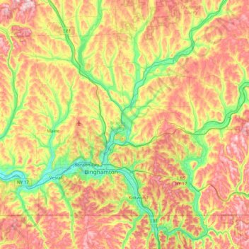
Name: Broome County topographic map, elevation, terrain.
Location: Broome County, New York, United States (41.99790 -76.13017 42.41554 -75.35955)
Average elevation: 413 m
Minimum elevation: 241 m
Maximum elevation: 635 m
Other topographic maps
Click on a map to view its topography, its elevation and its terrain.