
Thank you for supporting this site ❤️
Make a donation
Make a donation
Bragg Creek topographic map
Click on the map to display elevation.
Thank you for supporting this site ❤️
Make a donation
Make a donation
About this map
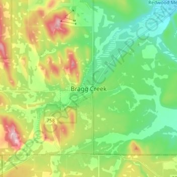
Name: Bragg Creek topographic map, elevation, terrain.
Location: Bragg Creek, Rocky View County, Alberta, T0L 0K0, Canada (50.91147 -114.60289 50.99147 -114.52289)
Average elevation: 1,332 m
Minimum elevation: 1,247 m
Maximum elevation: 1,494 m
Thank you for supporting this site ❤️
Make a donation
Make a donation
Other topographic maps
Click on a map to view its topography, its elevation and its terrain.
Thank you for supporting this site ❤️
Make a donation
Make a donation
Langdon
Canada > Alberta > Rocky View County
Langdon is located 12 km (7.5 mi) east of the City of Calgary at the intersection of Highway 560 (Glenmore Trail) and Highway 797, approximately 6 km (3.7 mi) south of the Trans Canada Highway and 7 km (4.3 mi) north of Highway 22X. It has an elevation of 1,005 m (3,297 ft).
Average elevation: 1,007 m