
Make a donation
Göhl topographic map
Click on the map to display elevation.
Make a donation
About this map
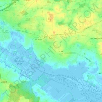
Name: Göhl topographic map, elevation, terrain.
Average elevation: 8 m
Minimum elevation: -4 m
Maximum elevation: 26 m
Make a donation
Other topographic maps
Click on a map to view its topography, its elevation and its terrain.
Hohwachter Bucht
Deutschland > Schleswig-Holstein > Kreis Ostholstein > Gremersdorf
Average elevation: 5 m
Burg auf Fehmarn
Deutschland > Schleswig-Holstein > Kreis Ostholstein > Fehmarn
Average elevation: 6 m
Make a donation
Pelzerhaken
Deutschland > Schleswig-Holstein > Kreis Ostholstein > Neustadt in Holstein
Average elevation: 8 m
Putlos
Deutschland > Schleswig-Holstein > Kreis Ostholstein > Oldenburg in Holstein
Average elevation: 9 m
Taschensee
Deutschland > Schleswig-Holstein > Kreis Ostholstein > Scharbeutz > Gronenberg
Average elevation: 26 m
Make a donation
Make a donation
Anschottredder
Deutschland > Schleswig-Holstein > Kreis Ostholstein > Bujendorf
Average elevation: 51 m
Pönitz am See
Deutschland > Schleswig-Holstein > Kreis Ostholstein > Scharbeutz
Average elevation: 25 m
Make a donation
Make a donation
Holzbergturm
Deutschland > Schleswig-Holstein > Kreis Ostholstein > Malente > Neversfelde
Der erste Holzbergturm wurde im Jahr 2000 von Mitgliedern des Verschönerungsvereins Neversfelde e.V. entworfen. Im Juni 2004 begannen die Bauarbeiten, die im Frühjahr 2005 abgeschlossen waren. Die Eröffnung des 28,5 Meter hohen, aus Lärchenholz errichteten Turms erfolgte im Juli 2005. Die Baukosten…
Average elevation: 40 m
Make a donation
Langenhagen
Deutschland > Schleswig-Holstein > Kreis Ostholstein > Schönwalde am Bungsberg
Average elevation: 110 m
Make a donation
Krummsee
Deutschland > Schleswig-Holstein > Kreis Ostholstein > Malente > Krummsee > Bruhnskoppel
Average elevation: 48 m
Neustädter Bucht
Deutschland > Schleswig-Holstein > Kreis Ostholstein > Neustadt in Holstein
Average elevation: 5 m
Make a donation
Grammdorf
Deutschland > Schleswig-Holstein > Kreis Ostholstein
Die Christuskirche wurde auf der Kammhöhe eines eiszeitlichen Moränenzuges errichtet. Der Bau wurde 1896 an der Stelle einer Kirche des 13. Jahrhunderts errichtet. Er weist an der südöstlichen Seite ein Feldsteinmauerwerk auf. Beim Bau verwendete der Hamburger Architekt Hugo Groothoff behauene Feldsteine…
Average elevation: 32 m
Make a donation