
Thank you for supporting this site ❤️
Make a donation
Make a donation
Lenste topographic map
Click on the map to display elevation.
Thank you for supporting this site ❤️
Make a donation
Make a donation
About this map
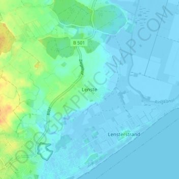
Name: Lenste topographic map, elevation, terrain.
Average elevation: 5 m
Minimum elevation: -8 m
Maximum elevation: 32 m
Thank you for supporting this site ❤️
Make a donation
Make a donation
Other topographic maps
Click on a map to view its topography, its elevation and its terrain.
23743
Deutschland > Schleswig-Holstein > Kreis Ostholstein > Grömitz > Lenste > Ziegelhof
Average elevation: 12 m