
Make a donation
DeLand topographic map
Click on the map to display elevation.
Make a donation
DeLand
DeLand features a varied topography characterized primarily by gentle slopes and a mix of wetlands and uplands. The city covers approximately 17.8 square miles, with about 17.6 square miles of land and a small percentage dedicated to water bodies. The elevation in DeLand is relatively modest, typically ranging from around 20 to 30 feet above sea level, contributing to its scenic vistas of rolling hills and lush landscapes. The area is interspersed with natural springs, and it is drained by the St. Johns River, which adds to the ecological diversity of the region. DeLand's terrain, alongside its humid subtropical climate, supports a rich variety of vegetation and wildlife, making it a picturesque setting for outdoor activities.
Make a donation
About this map
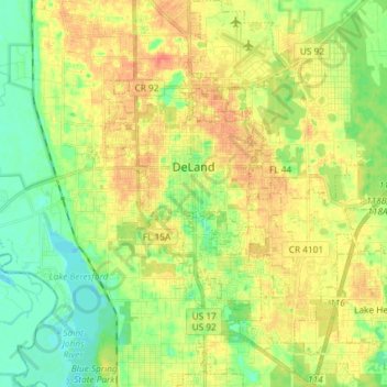
Name: DeLand topographic map, elevation, terrain.
Location: DeLand, Volusia County, Florida, 32723, United States (28.95548 -81.34314 29.08338 -81.23535)
Average elevation: 20 m
Minimum elevation: -1 m
Maximum elevation: 41 m
Make a donation
Other topographic maps
Click on a map to view its topography, its elevation and its terrain.
Samsula-Spruce Creek
United States > Florida > Volusia County > New Smyrna Beach > South Village
Average elevation: 8 m
Make a donation
Make a donation
Make a donation
Make a donation
Make a donation
Make a donation
Make a donation
Halifax Estates
United States > Florida > Volusia County > Daytona Beach Shores
Average elevation: 1 m
Cypress Lake Park
United States > Florida > Volusia County > Cypress Lake Estates
Average elevation: 22 m
Make a donation
Make a donation
Make a donation