
Luyando topographic map
Interactive map
Click on the map to display elevation.
About this map
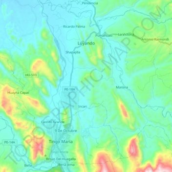
Name: Luyando topographic map, elevation, terrain.
Location: Luyando, Provincia de Leoncio Prado, Huánuco, Perú (-9.33024 -76.02441 -9.15190 -75.85362)
Average elevation: 778 m
Minimum elevation: 593 m
Maximum elevation: 1,610 m
Other topographic maps
Click on a map to view its topography, its elevation and its terrain.
Naranjillo
Naranjillo, Luyando, Leoncio Prado, Huánuco, Perú
Average elevation: 664 m