
West Tennessee topographic map
Interactive map
Click on the map to display elevation.
About this map
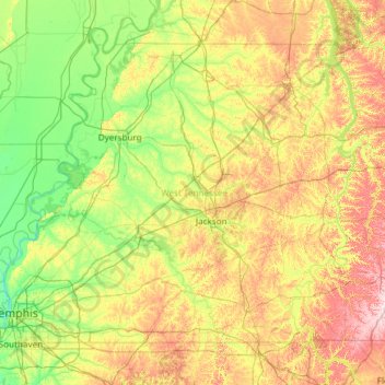
Name: West Tennessee topographic map, elevation, terrain.
Location: West Tennessee, Tennessee, United States (34.99372 -90.31030 36.50723 -87.91657)
Average elevation: 127 m
Minimum elevation: 56 m
Maximum elevation: 325 m
West Tennessee is located almost entirely within the Mississippi Embayment, part of the Gulf Coastal Plain. Because of this, the terrain is flatter than the eastern parts of the state. Areas along the Mississippi River are located within the Mississippi Alluvial Plain, which is primarily a floodplain with many swamps. However, much of the western counties of the region are protected from flooding by the Chickasaw Bluffs, ridges of loess rising 50 to 200 feet (15 to 61 m) above the floodplain. Although the land is lower and flatter than Middle and East Tennessee, some hilly terrain exists, especially along the bluffs bordering the Mississippi River and the land bordering the Tennessee River, known as the West Tennessee Highlands. Hilly land in these areas is forested. Otherwise, most of the land in West Tennessee is used as farmland. The soil in this part of the state comes from when a prehistoric sea dried up and left sediment in its place. Unlike in the rest of the state, bedrock is buried a few thousand feet below the surface. West Tennessee's highest elevation is approximately 840 feet (260 m) in Hardin County east of the Tennessee River, which is slightly lower than the state's mean elevation of 900 feet (270 m); the region's highest elevation west of the Tennessee River is approximately 740 feet (230 m) in Chester County.
Other topographic maps
Click on a map to view its topography, its elevation and its terrain.
Chattanooga
United States > Tennessee > Hamilton County
Chattanooga, Hamilton County, East Tennessee, Tennessee, United States
Average elevation: 331 m
Nashville-Davidson
United States > Tennessee > Davidson County
Nashville-Davidson, Davidson County, Middle Tennessee, Tennessee, United States
Average elevation: 184 m
Kingston
United States > Tennessee > Roane County
Kingston, Roane County, East Tennessee, Tennessee, United States
Average elevation: 260 m
Signal Mountain
United States > Tennessee > Hamilton County
Signal Mountain, Hamilton County, East Tennessee, Tennessee, 37377, United States
Average elevation: 493 m
Rock Creek
United States > Tennessee > Unicoi County > Erwin
Rock Creek, Erwin, Unicoi County, East Tennessee, Tennessee, 37650, United States
Average elevation: 608 m
Weakley County
Weakley County, West Tennessee, Tennessee, United States
Average elevation: 121 m
Lake
Lake, Lake County, West Tennessee, Tennessee, United States
Average elevation: 100 m
Rutherford County
Rutherford County, Middle Tennessee, Tennessee, United States
Average elevation: 222 m
Grainger County
Grainger County, East Tennessee, Tennessee, United States
Average elevation: 388 m
Washington County
Washington County, East Tennessee, Tennessee, United States
Average elevation: 567 m
Lee Valley
United States > Tennessee > Hawkins County
Lee Valley, Hawkins County, East Tennessee, Tennessee, United States
Average elevation: 531 m
Lettie Kendall Park
United States > Tennessee > Montgomery County > Clarksville
Lettie Kendall Park, Clarksville, Montgomery County, Middle Tennessee, Tennessee, United States
Average elevation: 136 m
Jackson
United States > Tennessee > Madison County
Jackson, Madison County, West Tennessee, Tennessee, United States
Average elevation: 129 m
Lone Oak
United States > Tennessee > Sequatchie County
Lone Oak, Sequatchie County, Middle Tennessee, Tennessee, United States
Average elevation: 593 m
Rhea County
Rhea County, East Tennessee, Tennessee, United States
Average elevation: 378 m
Benton County
Benton County, West Tennessee, Tennessee, United States
Average elevation: 146 m
East Lake
United States > Tennessee > Hamilton County > Chattanooga > East Ridge
East Lake, East Ridge, Chattanooga, Hamilton County, East Tennessee, Tennessee, 37407, United States
Average elevation: 231 m
Germantown
United States > Tennessee > Shelby County
Germantown, Shelby County, West Tennessee, Tennessee, United States
Average elevation: 98 m
Durham Manor
United States > Tennessee > Williamson County
Durham Manor, Williamson County, Middle Tennessee, Tennessee, 37064, United States
Average elevation: 223 m
Cleveland
United States > Tennessee > Bradley County
Cleveland, Bradley County, Tennessee, United States
Average elevation: 264 m
Butler
United States > Tennessee > Johnson County
Butler, Johnson County, East Tennessee, Tennessee, United States
Average elevation: 671 m
Hamilton County
Hamilton County, East Tennessee, Tennessee, United States
Average elevation: 340 m
Sevierville
United States > Tennessee > Sevier County
Sevierville, Sevier County, Tennessee, United States
Average elevation: 305 m
Pleasant View
United States > Tennessee > Cheatham County
Pleasant View, Cheatham County, Middle Tennessee, Tennessee, 37146, United States
Average elevation: 204 m
Claiborne County
Claiborne County, East Tennessee, Tennessee, United States
Average elevation: 451 m
Sevier County
Sevier County, East Tennessee, Tennessee, United States
Average elevation: 599 m
Battery Heights
United States > Tennessee > Hamilton County > Chattanooga
Battery Heights, Chattanooga, Hamilton County, Tennessee, 37406, United States
Average elevation: 221 m
Crockett County
Crockett County, West Tennessee, Tennessee, United States
Average elevation: 102 m
Isabella
United States > Tennessee > Polk County
Isabella, Polk County, Tennessee, 37326, United States
Average elevation: 516 m
Spring City
United States > Tennessee > Rhea County
Spring City, Rhea County, Tennessee, United States
Average elevation: 252 m
Speedwell
United States > Tennessee > Claiborne County
Speedwell, Claiborne County, Tennessee, 37870, United States
Average elevation: 416 m
Shadowlawn
United States > Tennessee > Shelby County > Memphis
Shadowlawn, Memphis, Shelby County, West Tennessee, Tennessee, 38126, United States
Average elevation: 89 m
Pisgah Heights
United States > Tennessee > Shelby County > Memphis
Pisgah Heights, Memphis, Shelby County, West Tennessee, Tennessee, 38109, United States
Average elevation: 78 m
J. Percy Priest Lake
United States > Tennessee > Davidson County > Nashville-Davidson
J. Percy Priest Lake, Nashville-Davidson, Davidson County, Middle Tennessee, Tennessee, United States
Average elevation: 169 m
Riverside
United States > Tennessee > Maury County > Columbia
Riverside, Columbia, Maury County, Tennessee, 38401, United States
Average elevation: 195 m
Pegram
United States > Tennessee > Cheatham County
Pegram, Cheatham County, Tennessee, 37143, United States
Average elevation: 195 m
Halls Crossroads
United States > Tennessee > Knox County
Halls Crossroads, Knox County, East Tennessee, Tennessee, United States
Average elevation: 346 m
Obion County
Obion County, West Tennessee, Tennessee, United States
Average elevation: 103 m
Old Farm
United States > Tennessee > Hamilton County > Chattanooga
Old Farm, Chattanooga, Hamilton County, Tennessee, 37419, United States
Average elevation: 261 m
East Brainerd
United States > Tennessee > Hamilton County > Chattanooga
East Brainerd, Chattanooga, Hamilton County, Tennessee, 30726, United States
Average elevation: 225 m
Matlock Ford
United States > Tennessee > Hickman County > Matlock Ford
Matlock Ford, Hickman County, Tennessee, 37137, United States
Average elevation: 180 m
Antioch
United States > Tennessee > Davidson County > Nashville-Davidson > Antioch
Antioch, Nashville-Davidson, Davidson County, Tennessee, 37011, United States
Average elevation: 175 m
Fort Granger
United States > Tennessee > Williamson County > Franklin
Fort Granger, Rolling Rivers, Franklin, Williamson County, Tennessee, United States
Average elevation: 203 m
Forest Hills
United States > Tennessee > Davidson County > Forest Hills
Forest Hills, Davidson County, Tennessee, United States
Average elevation: 218 m
Elk River
Elk River, Tennessee, 37334, United States
Average elevation: 270 m
College Grove
United States > Tennessee > Roane County > Rockwood > College Grove
College Grove, Rockwood, Roane County, Tennessee, United States
Average elevation: 277 m
Clairfield
United States > Tennessee > Claiborne County > Clairfield
Clairfield, Claiborne County, Tennessee, 37715, United States
Average elevation: 455 m
Jason Chapel
United States > Tennessee > Dickson County > Jason Chapel
Jason Chapel, Dickson County, Tennessee, United States
Average elevation: 246 m
Memphis
United States > Tennessee > Shelby County > Memphis
Memphis, Shelby County, West Tennessee, Tennessee, 38112, United States
Average elevation: 85 m
Ooltewah
United States > Tennessee > Hamilton County
Ooltewah, Hamilton County, East Tennessee, Tennessee, United States
Average elevation: 267 m