
Make a donation
Chattanooga topographic map
Click on the map to display elevation.
Make a donation
Chattanooga
The city, with a downtown elevation of about 680 feet (210 m), is at the transition between the ridge-and-valley portion of the Appalachian Mountains and the Cumberland Plateau. Its official nickname is "Scenic City", alluding to the surrounding by mountains and ridges. Unofficial nicknames include "River City", "Chatt", "Nooga", "Chattown", and "Gig City", the latter a reference to Chattanooga's claims that it has the fastest internet service in the Western Hemisphere.
Make a donation
About this map
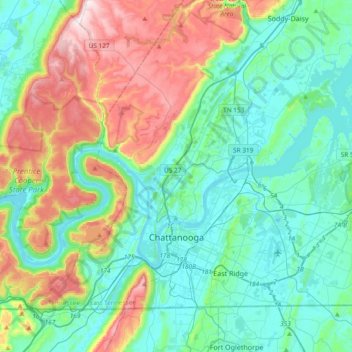
Name: Chattanooga topographic map, elevation, terrain.
Average elevation: 331 m
Minimum elevation: 189 m
Maximum elevation: 722 m
Make a donation
Other topographic maps
Click on a map to view its topography, its elevation and its terrain.
Ridgedale
United States > Tennessee > Hamilton County > Chattanooga > Ridgeside
Average elevation: 234 m
Make a donation
Brainerd
United States > Tennessee > Hamilton County > Chattanooga > Ridgeside
Average elevation: 234 m
Shepherd Forest
United States > Tennessee > Hamilton County > Signal Mountain
Average elevation: 459 m
Make a donation
North Glen Estates
United States > Tennessee > Hamilton County > Chattanooga > Red Bank
Average elevation: 235 m
Make a donation
Mountain Ridge
United States > Tennessee > Hamilton County > Chattanooga > Red Bank
Average elevation: 249 m
Make a donation
Make a donation
Make a donation
Make a donation
Regency Place
United States > Tennessee > Hamilton County > Chattanooga > Ridgeside
Average elevation: 234 m
White Oak
United States > Tennessee > Hamilton County > Chattanooga > Red Bank
Average elevation: 242 m
Make a donation
Wilder Point
United States > Tennessee > Hamilton County > Signal Mountain > Palisades
Average elevation: 409 m
Make a donation
Make a donation
South Brainerd
United States > Tennessee > Hamilton County > Chattanooga > East Ridge
Average elevation: 223 m
Make a donation
Soddy-Daisy
United States > Tennessee > Hamilton County > Soddy-Daisy > Soddy-Daisy
Average elevation: 307 m
Northshore Estates
United States > Tennessee > Hamilton County > Chattanooga > Northshore Estates
Average elevation: 223 m
Make a donation
Brookfield
United States > Tennessee > Hamilton County > East Ridge > Brookfield
Average elevation: 235 m
Make a donation