
Saxony-Anhalt topographic map
Interactive map
Click on the map to display elevation.
Saxony-Anhalt
The Harz mountains are located in the south-west, comprising the Harz National Park, the Harz Foreland and Mansfeld Land. The highest mountain of the Harz (and of Northern Germany) is Brocken, with an elevation of 1,141 meters (3,735 ft). In this area, one can find the towns of Halberstadt, Wernigerode, Thale, Eisleben and Quedlinburg.
About this map
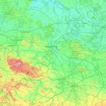
Name: Saxony-Anhalt topographic map, elevation, terrain.
Location: Saxony-Anhalt, Germany (50.93785 10.56074 53.04169 13.18688)
Average elevation: 133 m
Minimum elevation: 13 m
Maximum elevation: 1,099 m
Other topographic maps
Click on a map to view its topography, its elevation and its terrain.
Missen - Pšyne
Germany > Brandenburg > Oberspreewald-Lausitz - Górne Błota-Łužyca > Vetschau/Spreewald
Average elevation: 72 m
Leichlingen
Germany > North Rhine-Westphalia > Rheinisch-Bergischer Kreis > Leichlingen > Leichlingen
Average elevation: 95 m
Wehr (Mosel)
Germany > Rhineland-Palatinate > Landkreis Trier-Saarburg > Palzem > Wehr (Mosel)
Average elevation: 201 m