Geolocate

Tel Aviv topographic map

Interactive map

Click on the map to display elevation.

About this map

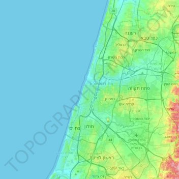
Name: Tel Aviv topographic map, elevation, terrain.

Location: Tel Aviv, 6473804, Israel (31.92530 34.62181 32.24530 34.94181)

Average elevation: 25 m

Minimum elevation: -1 m

Maximum elevation: 196 m

Other topographic maps

Click on a map to view its topography, its elevation and its terrain.

Jerusalem

Israel > Jerusalem District

Jerusalem is situated on the southern spur of a plateau in the Judaean Mountains, which include the Mount of Olives (East) and Mount Scopus (North East). The elevation of the Old City is approximately 760 m (2,490 ft). The whole of Jerusalem is surrounded by valleys and dry riverbeds (wadis). The Kidron,…

Average elevation: 639 m

Tel Aviv District

Israel

Average elevation: 24 m

Tamar Regional Council

Israel

Average elevation: 272 m

Rehovot

Israel > Center District > Rehovot

Average elevation: 54 m

Haifa

Israel > Haifa District > Haifa

Haifa is the center of liberal Arabic-speaking culture, as it was under British colonial rule. The Arabic-speaking neighborhoods, which are mixed Muslim and Christian, are in the lowlands near the sea, while Jewish neighborhoods are at higher elevation. An active Arab cultural life has developed in the 21st…

Average elevation: 74 m

Herzliya

Israel > Tel Aviv District > Herzliya

Average elevation: 38 m

North District

Israel > North District

Average elevation: 322 m

Bet Shemesh

Israel > Jerusalem District > Bet Shemesh

Average elevation: 328 m

Mt. Hermon

Israel > North District > Golan Regional Council

Average elevation: 2,016 m

Jerusalem District

Israel

Average elevation: 489 m