
Manchester topographic map
Click on the map to display elevation.
About this map
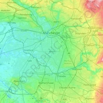
Name: Manchester topographic map, elevation, terrain.
Location: Manchester, Greater Manchester, England, United Kingdom (53.34010 -2.31992 53.54459 -2.14683)
Average elevation: 66 m
Minimum elevation: 12 m
Maximum elevation: 236 m
Other topographic maps
Click on a map to view its topography, its elevation and its terrain.
Lydney Harbour
United Kingdom > England > Gloucestershire > Forest of Dean > Lydney > Naas
Average elevation: 7 m
Hyde Park
United Kingdom > England > London
"It consists of a screen of handsome fluted Ionic columns, with three carriage entrance archways, two-foot entrances, a lodge, etc. The extent of the whole frontage is about 107 ft (33 m). The central entrance has a bold projection: the entablature is supported by four columns; and the volutes of the capitals…
Average elevation: 25 m
Highbury
United Kingdom > England > Gloucestershire > Forest of Dean > Lydney > Allaston
Average elevation: 68 m
Allesley
United Kingdom > England > West Midlands Combined Authority > Coventry > Allesley
Average elevation: 115 m