
Make a donation
Dana topographic map
Click on the map to display elevation.
Make a donation
About this map
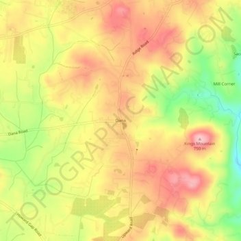
Name: Dana topographic map, elevation, terrain.
Location: Dana, Henderson County, North Carolina, 28724, United States (35.30928 -82.39540 35.34928 -82.35540)
Average elevation: 669 m
Minimum elevation: 573 m
Maximum elevation: 737 m
Make a donation
Other topographic maps
Click on a map to view its topography, its elevation and its terrain.
Mills River
United States > North Carolina > Henderson County > Mills River > Oak Hill Court
Average elevation: 633 m
Echo Lake
United States > North Carolina > Henderson County > Laurel Park > Country Ridge
Average elevation: 760 m
Make a donation
Etowah
United States > North Carolina > Henderson County > Etowah
Etowah has an altitude of 2,101 feet (640 m).
Average elevation: 652 m
Barker Heights
United States > North Carolina > Henderson County > Barker Heights
Average elevation: 643 m
East Flat Rock
United States > North Carolina > Henderson County > Ridgeview Estates
Average elevation: 655 m
Make a donation
Mills River
United States > North Carolina > Henderson County > Mills River > Oak Hill Court
Average elevation: 644 m