
Thank you for supporting this site ❤️
Make a donation
Make a donation
Etowah topographic map
Click on the map to display elevation.
Thank you for supporting this site ❤️
Make a donation
Make a donation
Etowah
Etowah has an altitude of 2,101 feet (640 m).
Thank you for supporting this site ❤️
Make a donation
Make a donation
About this map
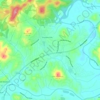
Name: Etowah topographic map, elevation, terrain.
Location: Etowah, Henderson County, North Carolina, United States (35.29686 -82.61836 35.34059 -82.57144)
Average elevation: 652 m
Minimum elevation: 621 m
Maximum elevation: 741 m
Thank you for supporting this site ❤️
Make a donation
Make a donation