
Sungai Satui topographic map
Interactive map
Click on the map to display elevation.
About this map
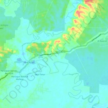
Name: Sungai Satui topographic map, elevation, terrain.
Location: Sungai Satui, Süd-Kalimantan, Indonesien (-3.81319 115.40622 -3.73742 115.48383)
Average elevation: 9 m
Minimum elevation: -3 m
Maximum elevation: 58 m
Other topographic maps
Click on a map to view its topography, its elevation and its terrain.
Tanah Bumbu
Tanah Bumbu, Süd-Kalimantan, Kalimantan, 72273, Indonesien
Average elevation: 90 m
Gunung Mas
Indonesien > Süd-Kalimantan > Gunung Mas
Gunung Mas, Süd-Kalimantan, Indonesien
Average elevation: 34 m
Lungau
Indonesien > Süd-Kalimantan > Hulu Sungai Selatan
Lungau, Hulu Sungai Selatan, Süd-Kalimantan, Kalimantan, Indonesien
Average elevation: 6 m