
Thank you for supporting this site ❤️
Make a donation
Make a donation
Dinagat Island topographic map
Click on the map to display elevation.
Thank you for supporting this site ❤️
Make a donation
Make a donation
About this map
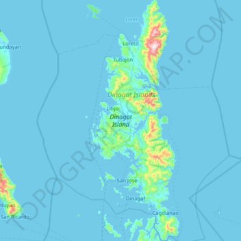
Name: Dinagat Island topographic map, elevation, terrain.
Location: Dinagat Island, Dinagat Islands, Caraga, Philippines (9.85214 125.47344 10.47158 125.70699)
Average elevation: 29 m
Minimum elevation: -1 m
Maximum elevation: 907 m
Thank you for supporting this site ❤️
Make a donation
Make a donation