
South Cotabato topographic map
Interactive map
Click on the map to display elevation.
South Cotabato
Maximum daytime temperature throughout the province is in the range of 36 to 38 °C (97 to 100 °F), falling to 23 to 32 °C (73 to 90 °F) during the night depending on the elevation. The hottest period is January to April while July to December being the coolest.
About this map
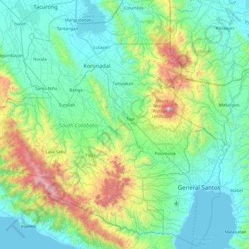
Name: South Cotabato topographic map, elevation, terrain.
Location: South Cotabato, Soccsksargen, Philippines (5.92838 124.24390 6.66302 125.27588)
Average elevation: 352 m
Minimum elevation: -4 m
Maximum elevation: 2,240 m
Other topographic maps
Click on a map to view its topography, its elevation and its terrain.
Lake Sebu
The placid lake of Lake Sebu can be found in Allah Valley near the municipality of Surallah, South Cotabato. Surrounded by rolling hills and mountains covered with thick rain forest, the lake has an area of 354 hectares (870 acres), with an elevation of approximately 1,000 metres (3,300 ft).
Average elevation: 750 m