
Albert County topographic map
Interactive map
Click on the map to display elevation.
About this map
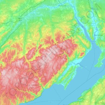
Name: Albert County topographic map, elevation, terrain.
Location: Albert County, New Brunswick, Canada (45.51329 -65.22316 46.09187 -64.54696)
Average elevation: 125 m
Minimum elevation: 0 m
Maximum elevation: 420 m
Other topographic maps
Click on a map to view its topography, its elevation and its terrain.
Clarendon Parish
Clarendon Parish, Charlotte County, New Brunswick, Canada
Average elevation: 160 m
Saint Quentin Parish
Saint Quentin Parish, Restigouche County, New Brunswick, E8A 1H5, Canada
Average elevation: 341 m
Clarendon Parish
Clarendon Parish, Charlotte County, New Brunswick, Canada
Average elevation: 160 m
Fundy National Park of Canada
Fundy National Park of Canada, 114, Albert County, New Brunswick, E4H 1N5, Canada
Average elevation: 230 m