
Michigan topographic map
Interactive map
Click on the map to display elevation.
About this map
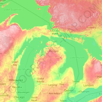
Name: Michigan topographic map, elevation, terrain.
Location: Michigan, United States (41.69613 -90.41862 48.30606 -82.12281)
Average elevation: 259 m
Minimum elevation: 169 m
Maximum elevation: 653 m
The heavily forested Upper Peninsula is relatively mountainous in the west. The Porcupine Mountains, which are part of one of the oldest mountain chains in the world, rise to an altitude of almost 2,000 feet (610 m) above sea level and form the watershed between the streams flowing into Lake Superior and Lake Michigan. The surface on either side of this range is rugged. The state's highest point, in the Huron Mountains northwest of Marquette, is Mount Arvon at 1,979 feet (603 m). The peninsula is as large as Connecticut, Delaware, Massachusetts, and Rhode Island combined but has fewer than 330,000 inhabitants. They are sometimes called "Yoopers" (from "U.P.'ers"), and their speech (the "Yooper dialect") has been heavily influenced by the numerous Scandinavian and Canadian immigrants who settled the area during the lumbering and mining boom of the late 19th century.
Other topographic maps
Click on a map to view its topography, its elevation and its terrain.
Santa Barbara
United States > California > Santa Barbara County
Santa Barbara, Santa Barbara County, California, United States
Average elevation: 119 m
Santa Cruz
United States > California > Santa Cruz County
Santa Cruz, Santa Cruz County, California, United States
Average elevation: 89 m
Brooklyn
United States > New York > New York
Brooklyn, Kings County, New York, United States
Average elevation: 9 m
Aurora
United States > Colorado > Adams County
Aurora, Adams County, Colorado, United States
Average elevation: 1,691 m
Albuquerque
United States > New Mexico > Bernalillo County
Albuquerque, Bernalillo County, New Mexico, United States
Average elevation: 1,688 m
Allegheny County
Allegheny County, Pennsylvania, United States
Average elevation: 325 m
Jacksonville
United States > Florida > Duval County
Jacksonville, Duval County, Florida, United States
Average elevation: 10 m
Cape Cod
United States > Massachusetts > Plymouth County
Cape Cod, Plymouth County, Massachusetts, United States
Average elevation: 2 m
Indianapolis
United States > Indiana > Indianapolis
Indianapolis, Marion County, Indiana, 46204, United States
Average elevation: 241 m
Tampa
United States > Florida > Hillsborough County
Tampa, Hillsborough County, Florida, United States
Average elevation: 11 m
Knoxville
United States > Tennessee > Knox County
Knoxville, Knox County, East Tennessee, Tennessee, United States
Average elevation: 307 m
Hudson River
Hudson River, New Jersey, 12834:12871, United States
Average elevation: 297 m
Oakland County
Oakland County, Michigan, United States
Average elevation: 282 m
Waltham
United States > Massachusetts > Middlesex County
Waltham, Middlesex County, Massachusetts, United States
Average elevation: 48 m
Yosemite National Park
Yosemite National Park, California, United States
Average elevation: 2,337 m
Spokane
United States > Washington > Spokane County
Spokane, Spokane County, Washington, United States
Average elevation: 655 m
Atlantic City
United States > New Jersey > Atlantic County
Atlantic City, Atlantic County, New Jersey, 08401, United States
Average elevation: 1 m