Geolocate

Attica topographic map

Interactive map

Click on the map to display elevation.

About this map

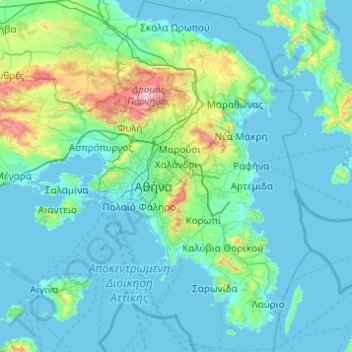
Name: Attica topographic map, elevation, terrain.

Location: Attica, Greece (37.64831 23.10669 38.34101 24.08594)

Average elevation: 133 m

Minimum elevation: -1 m

Maximum elevation: 1,384 m

Other topographic maps

Click on a map to view its topography, its elevation and its terrain.

Vouliagmeni Municipal Unit

Greece > Attica > Regional Unit of East Attica

Vouliagmeni Municipal Unit, Municipality of Vari - Voula - Vouliagmeni, Regional Unit of East Attica, Attica, 166 71, Greece

Average elevation: 20 m

Piraeus

Greece > Attica > Regional Unit of Piraeus

Piraeus, Municipality of Piraeus, Regional Unit of Piraeus, Attica, 185 35, Greece

Average elevation: 96 m

Salamis

Greece > Attica > Regional Unit of Islands > Ampelakia Municipal Unit

Salamis, Ampelakia Municipal Unit, Municipality of Salamina, Regional Unit of Islands, Attica, Greece

Average elevation: 38 m

Municipality of Marousi

Greece > Attica > Regional Unit of North Athens

Municipality of Marousi, Regional Unit of North Athens, Attica, Greece

Average elevation: 224 m

Athens

Greece > Attica > Regional Unit of Central Athens

Athens, Municipality of Athens, Regional Unit of Central Athens, Attica, 105 57, Greece

Average elevation: 168 m

Municipality of Ilion

Greece > Attica

Municipality of Ilion, Regional Unit of West Athens, Region of Attica, Attica, Greece

Average elevation: 113 m

Attica

Greece > Attica

Attica, Greece

Average elevation: 155 m

3η Δημοτική Κοινότητα Αθηνών

Greece > Attica > 3η Δημοτική Κοινότητα Αθηνών

3η Δημοτική Κοινότητα Αθηνών, Municipality of Athens, Regional Unit of Central Athens, Region of Attica, Attica, 11852, Greece

Average elevation: 50 m