
Attica topographic map
Interactive map
Click on the map to display elevation.
About this map
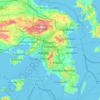
Name: Attica topographic map, elevation, terrain.
Location: Attica, Greece (37.64831 23.10669 38.34101 24.08594)
Average elevation: 133 m
Minimum elevation: -1 m
Maximum elevation: 1,384 m
Other topographic maps
Click on a map to view its topography, its elevation and its terrain.
Athens
Greece > Attica > Regional Unit of Central Athens
The southern section of the Athens metropolitan area (i.e., Elliniko, Athens Riviera) lies in the transitional zone between Mediterranean (Csa) and hot semi-arid climate (BSh), with its port-city of Piraeus being the most extreme example, receiving just 331.9 millimetres (13.07 in) per year. The areas to the…
Average elevation: 168 m