
Patate topographic map
Interactive map
Click on the map to display elevation.
About this map
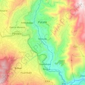
Name: Patate topographic map, elevation, terrain.
Location: Patate, Tungurahua, 180550, Ecuador (-1.40666 -78.51938 -1.27892 -78.43941)
Average elevation: 2,653 m
Minimum elevation: 1,812 m
Maximum elevation: 3,830 m
Other topographic maps
Click on a map to view its topography, its elevation and its terrain.
Yamate
Ecuador > Tungurahua > Patate > Patate
Yamate, Patate, Tungurahua, 180550, Ecuador
Average elevation: 2,446 m
Columbia
Ecuador > Tungurahua > Patate > Patate
Columbia, Patate, Tungurahua, 180550, Ecuador
Average elevation: 2,454 m
San Javier
Ecuador > Tungurahua > Patate > Patate
San Javier, Patate, Tungurahua, 180550, Ecuador
Average elevation: 2,269 m