
Williamsburg topographic map
Interactive map
Click on the map to display elevation.
About this map
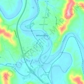
Name: Williamsburg topographic map, elevation, terrain.
Location: Williamsburg, Whitley County, Kentucky, 40769, United States (36.71760 -84.18841 36.76216 -84.14341)
Average elevation: 322 m
Minimum elevation: 274 m
Maximum elevation: 513 m
Other topographic maps
Click on a map to view its topography, its elevation and its terrain.
Rockholds
United States > Kentucky > Whitley County
Rockholds, Whitley County, Kentucky, United States
Average elevation: 348 m
S&J Garden
United States > Kentucky > Whitley County > Corbin
S&J Garden, Corbin, Whitley County, Kentucky, United States
Average elevation: 344 m
Corbin
United States > Kentucky > Whitley County
Corbin, Whitley County, Kentucky, United States
Average elevation: 360 m