
Bømlo topographic map
Interactive map
Click on the map to display elevation.
About this map
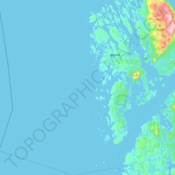
Name: Bømlo topographic map, elevation, terrain.
Location: Bømlo, Vestland, Norway (59.49613 4.60369 59.93862 5.47203)
Average elevation: 24 m
Minimum elevation: -1 m
Maximum elevation: 742 m
Other topographic maps
Click on a map to view its topography, its elevation and its terrain.
Halti
Halti (Finnish: Halti, rarely Haltiatunturi, Northern Sami: Háldičohkka, Swedish: Halde fjäll) is a fell at the border between Norway and Finland. The peak (elevation 1,365 m (4,478 ft)) of the fell, called Ráisduattarháldi, is in Norway, on the border between the municipalities of Nordreisa and…
Average elevation: 1,192 m