
Chelia topographic map
Interactive map
Click on the map to display elevation.
About this map
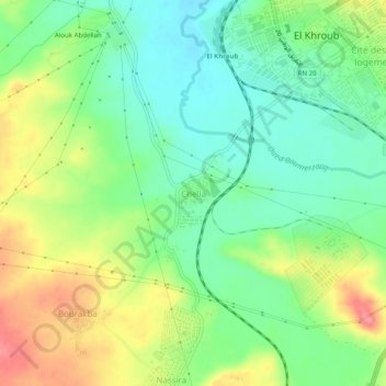
Name: Chelia topographic map, elevation, terrain.
Location: Chelia, El Khroub, Daïra El Khroub, Constantine, 25040, Algérie (36.22393 6.66121 36.26393 6.70121)
Average elevation: 624 m
Minimum elevation: 587 m
Maximum elevation: 681 m
Other topographic maps
Click on a map to view its topography, its elevation and its terrain.
Charchar
Algérie > Constantine > Daïra El Khroub > El Khroub
Charchar, El Khroub, Daïra El Khroub, Constantine, 25100, Algérie
Average elevation: 612 m
Oued Hammime
Algérie > Constantine > Daïra El Khroub > El Khroub
Oued Hammime, El Khroub, Daïra El Khroub, Constantine, Algérie
Average elevation: 685 m