
Oued Hammime topographic map
Interactive map
Click on the map to display elevation.
About this map
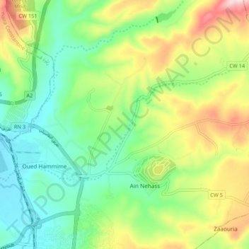
Name: Oued Hammime topographic map, elevation, terrain.
Location: Oued Hammime, El Khroub, Daïra El Khroub, Constantine, Algérie (36.29045 6.67837 36.32118 6.76018)
Average elevation: 685 m
Minimum elevation: 573 m
Maximum elevation: 887 m
Other topographic maps
Click on a map to view its topography, its elevation and its terrain.
Charchar
Algérie > Constantine > Daïra El Khroub > El Khroub
Charchar, El Khroub, Daïra El Khroub, Constantine, 25100, Algérie
Average elevation: 612 m
Chelia
Algérie > Constantine > Daïra El Khroub > El Khroub
Chelia, El Khroub, Daïra El Khroub, Constantine, 25040, Algérie
Average elevation: 624 m