
Manabí topographic map
Interactive map
Click on the map to display elevation.
About this map
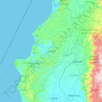
Name: Manabí topographic map, elevation, terrain.
Location: Manabí, Ecuador (-1.95153 -81.08477 0.37573 -79.40647)
Average elevation: 321 m
Minimum elevation: -2 m
Maximum elevation: 4,446 m
Other topographic maps
Click on a map to view its topography, its elevation and its terrain.
Quito
Ecuador > Pichincha > Quito Canton
Quito's elevation of 2,850 m (9,350 ft) makes it either the highest or the second highest capital city in the world. This varied standing is because Bolivia is a country with multiple capitals; if La Paz is considered the Bolivian national capital, it tops the list of highest capitals, but if Sucre is…
Average elevation: 2,930 m