
Quito topographic map
Click on the map to display elevation.
Quito
Quito's elevation of 2,850 meters (9,350 ft) makes it either the highest or the second-highest national capital city in the world. This varied standing is because Bolivia is a country with multiple capitals; if La Paz is considered the Bolivian national capital, it tops the list of highest capitals, but if Sucre is specified as the capital, then it is the second highest behind Quito.
About this map
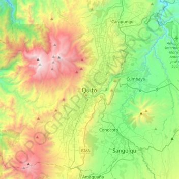
Name: Quito topographic map, elevation, terrain.
Location: Quito, Quito Canton, Pichincha, 170130, Ecuador (-0.38016 -78.67233 -0.06016 -78.35233)
Average elevation: 2,930 m
Minimum elevation: 1,897 m
Maximum elevation: 4,737 m
Other topographic maps
Click on a map to view its topography, its elevation and its terrain.
Cumbaya
At an elevation of 2200 m (7200 ft) above sea level, Cumbayá is lower than Quito and its climate is about 2 to 5 degrees Celsius warmer. Weather is semi tropical year-round, with a short rainy season.
Average elevation: 2,444 m
Guayllabamba
Guayllabamba (Kichwa: Wayllapampa, "green plain") is a small agricultural town (administratively, a rural parish of the canton of Quito) located 29 kilometers northeast of the city of Quito in northern Ecuador. In the 2001 census, the parish had a population of 12,227. The elevation is 2,142 metres (7,028 ft)…
Average elevation: 2,275 m
Cumbaya
At an elevation of 2200 m (7200 ft) above sea level, Cumbayá is lower than Quito and its climate is about 2 to 5 degrees Celsius warmer. Weather is semi tropical year-round, with a short rainy season.
Average elevation: 2,444 m