Geolocate

Little Guilin topographic map

Interactive map

Click on the map to display elevation.

About this map

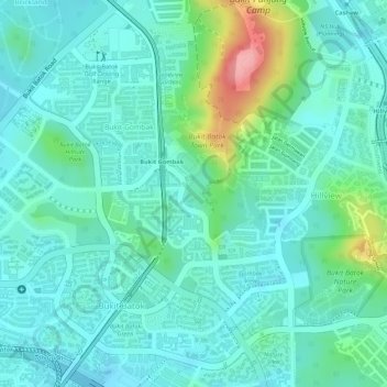
Name: Little Guilin topographic map, elevation, terrain.

Location: Little Guilin, Bukit Batok East Park Connector, Bukit Gombak, Bukit Batok, Southwest, 650257, Singapore (1.35469 103.75335 1.35747 103.75596)

Average elevation: 38 m

Minimum elevation: 8 m

Maximum elevation: 135 m

Other topographic maps

Click on a map to view its topography, its elevation and its terrain.

Singapore

Singapore > Central

The Central Region of Singapore, encompassing approximately 132.7 square kilometers (51.2 square miles), features a diverse topography characterized by both hilly terrains and flat coastal areas. Dominating the landscape is Bukit Timah Hill, the nation's highest natural point at 164 meters (538 feet), composed…

Average elevation: 11 m

Singapore

Singapore > Central > Singapore

Average elevation: 8 m

Fernvale

Singapore > Fernvale

Average elevation: 16 m

Yishun

Singapore > Yishun

Average elevation: 15 m

Southwest

Singapore

Average elevation: 8 m

Northwest

Singapore

Average elevation: 19 m

Southeast

Singapore

Average elevation: 5 m

Pulau Ubin

Singapore

Average elevation: 6 m

Northeast

Singapore

Average elevation: 13 m

Mei Hwan

Singapore > Mei Hwan

Average elevation: 20 m

Palau Tekong Camp

Singapore > Kampong Ladang

Average elevation: 5 m

Central

Singapore

Average elevation: 13 m