Geolocate

Pulau Ubin topographic map

Interactive map

Click on the map to display elevation.

About this map

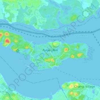
Name: Pulau Ubin topographic map, elevation, terrain.

Location: Pulau Ubin, Southeast, 508309, Singapore (1.39936 103.92622 1.42768 103.99238)

Average elevation: 6 m

Minimum elevation: -10 m

Maximum elevation: 60 m

Other topographic maps

Click on a map to view its topography, its elevation and its terrain.

HortPark

Singapore > Southwest > Singapore

Average elevation: 21 m

Bishan-Ang Mo Kio Park

Singapore

Average elevation: 21 m

Jurong Hill Park

Singapore > Southwest

Average elevation: 11 m

Singapore

Singapore > Central > Singapore

Average elevation: 8 m

Bukit Batok Nature Park

Singapore > Southwest

The peak of Bukit Batok Hill stands at an elevation of 107m above sea level. Temperature ranges from 23°C to 30°C during "Winter/Wet" season. During Summer, temperature ranges from 24°C to 33°C.

Average elevation: 45 m

Jurong Island

Singapore

Average elevation: 1 m

Fernvale

Singapore > Fernvale

Average elevation: 16 m

Yishun

Singapore > Yishun

Average elevation: 15 m

Little Guilin

Singapore

Average elevation: 38 m

Bedok Reservoir

Singapore

Average elevation: 23 m

Sungei Buloh

Singapore

Average elevation: 8 m

Bishan Active Park

Singapore > Singapore

Average elevation: 19 m

Mei Hwan

Singapore > Mei Hwan

Average elevation: 20 m

Kent Ridge Park

Singapore

Average elevation: 21 m

Raffles Lighthouse

Singapore

Average elevation: 1 m