
Milos topographic map
Interactive map
Click on the map to display elevation.
About this map
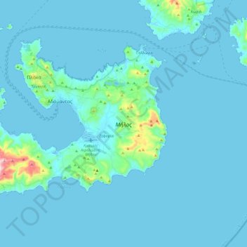
Name: Milos topographic map, elevation, terrain.
Average elevation: 24 m
Minimum elevation: -1 m
Maximum elevation: 391 m
Die Insel umschließt fast vollständig eine ausgedehnte Bucht, an der die wenigen Hafen-Dörfer liegen. Die höchste Erhebung ist mit 748 Metern Höhe der Profitis Ilias im Westen der Insel. Die Felsenküste um den flacheren Ostteil der Insel wird von einigen Stränden gesäumt, die vor allem durch vielfarbige Gesteine und Sande auffallen.
Other topographic maps
Click on a map to view its topography, its elevation and its terrain.
Sifnos
Griechenland > Ägäis > Regionalbezirk Milos > Πλατύς Γιαλός
Sifnos, Πλατύς Γιαλός, Δήμος Σίφνου, Regionalbezirk Milos, Region Südliche Ägäis, Ägäis, 840 03, Griechenland
Average elevation: 61 m