
La Touche topographic map
Interactive map
Click on the map to display elevation.
About this map
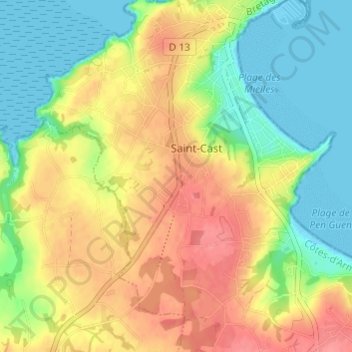
Name: La Touche topographic map, elevation, terrain.
Average elevation: 33 m
Minimum elevation: -1 m
Maximum elevation: 69 m
Other topographic maps
Click on a map to view its topography, its elevation and its terrain.
La Corvais
France > Bretagne > Côtes-d'Armor > Saint-Cast-le-Guildo > Saint-Cast
La Corvais, Saint-Cast, Saint-Cast-le-Guildo, Dinan, Côtes-d'Armor, Bretagne, France métropolitaine, 22380, France
Average elevation: 30 m
La Bassière
France > Bretagne > Côtes-d'Armor > Saint-Cast-le-Guildo > Saint-Cast
La Bassière, Saint-Cast, Saint-Cast-le-Guildo, Dinan, Côtes-d'Armor, Bretagne, France métropolitaine, 22380, France
Average elevation: 32 m